Fairmount is a town located at the junction of GA Highway 53 and US Highway 411. The town was incorporated on August 6, 1908 but appears on maps as Fair Mount as early as 1855. At one time it was the only Gordon County town on the old Tennessee Road for stage coaches. According to Ted Smith and Kenneth Krakow, Fairmount was named by early settlers for their home in Fairmont, West Virginia, and the name changed through the years to Fairmount. More likely, the settlers were from western Virginia and named Fairmount for their home in Fairmont, Virginia. West Virginia did not become a state until after the Civil War. Fairmont, Virginia was a blend of “fair” (beautiful) and “mont” (mountain) which would certainly seem to apply to the area in which Fairmount is located. (CT, GPN, CVI)
Archive for the ‘F’ Category
FAIRMOUNT
December 27, 2009FAMBRO
December 27, 2009Fambro appears on maps in 1899 and 1915. It was in the eastern part of the county on Sallacoa Creek near Dews Pond.
FARMVILLE
December 27, 2009Farmville is a community about five miles east of I-75 on GA Highway 53. It appears first on the 1899 map (on the 1915 map it is listed as Farmsville). The name probably came from the fact that the area around Farmville was prime agricultural land, and there were many farms. (CT)
FIDELLE
December 27, 2009 Fidelle is a small community on GA Highway 136 east of Nickelsville at the intersection of Maple Grove Church Road and Evergreen Road. At one time Evergreen Road was named Fidelle Road. The name still exists at the Fidelle Cemetery. Fidelle first appears on a map in 1899. A theory is that Fidelle was derived from the Latin word, “fidelis” meaning, “faithful.” This idea seems possible even though an extra “l” exists in Fidelle. Why this name would have been applied to the particular place is not known. (CT)
FIELD’S FERRY
December 27, 2009Field’s Ferry is the name of the Calhoun municipal golf course, located off Hunt’s Gin Road near Red Bud. Originally, the name came from a ferry on the Oostanaula River, operated by James Field and his son, Elias. The Fields owned a large farm in this area. Descendants of the original family still live in this area. (Joanne Owens)
FIELD’S MILL
December 27, 2009Field’s Mill, located in the same area as Field’s Ferry Golf Course, appears on a map in 1883. It was probably a mill operated by the Field’s family discussed in the entry on Field’s Ferry. (CVI, BL)
FINCHER
December 27, 2009Fincher is listed in Hemperley’s Cities, Towns and Communities of Georgia. It appears on no maps.
FITE BEND
December 27, 2009Fite Bend is a community located at a bend of the Conasauga River east of Resaca and just north of New Echota. Fite Bend runs south from Georgia Highway 136 about a half mile east of Resaca. It was named for the Peter Fite family, who owned land in the area. (CT)
FOLSOM
December 27, 2009Folsom is located in Bartow County off GA Highway 140 between Pine Log and Adairsville. According to Aubrey Adcock, the name may have come from Frances Folsom, the wife of former President Grover Cleveland; of course, Aub had a good sennse of humor. Folsom also could have been named for a local family, but so far no confirmation of this idea has been found. (Aubrey Adcock)
FORK FERRY (THE FORK)
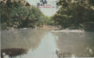
December 27, 2009 The confluence of the Coosawattee and Conasauga Rivers near the Elks Club off GA Highway 225, was known as “The Fork” by local people even before the removal of the Cherokees in 1838. A ferry operated there for many years. The post card view that illustrates this entry dates from around 1907 and indicates that the name, and possibly the ferry, was still used at that time. See the entry on Gansagi. (Jim Lay, BL)